Reaches · October 2025
The bluff above the river at low water
The only high ground for two hundred miles, and the one place where the whole river is visible at once.
- Where
- Fourth Chickasaw Bluff, Memphis
- Water
- 4.2 ft, falling
- On foot
- Two miles, paved, some steps
- Written by
- Hollis Mabry
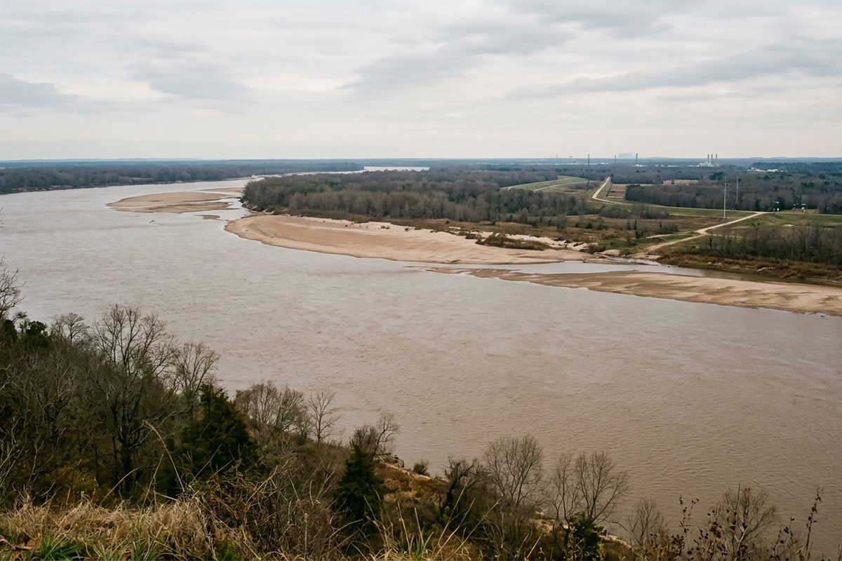
There is no high ground in the lower Mississippi valley. The plain is flat for two hundred miles in every direction except one: here, where a line of loess bluffs stands sixty feet above the water, and where every settlement on this stretch of river was therefore built.
The city sits on the fourth of them. From the edge you can see the whole river at once, which is rarer than it sounds, because almost everywhere else the levee is higher than you are.
What low water shows
At four feet on the Memphis gauge the river is doing something it does for perhaps two months a year. The channel narrows to less than half the width between the banks, and everything that was under water comes up: sandbars, mud flats, the tops of old revetment, the wrecks of things nobody records.
The bars are the interesting part. They are pale, almost white in flat light, and they change shape between years rather than between seasons. A bar that carried willows last autumn can be bare sand this one.
The river is not narrower at low water. It is the same river with its edges showing.
Tows work a tighter channel at this stage and they work it carefully. Watching a fifteen barge tow turn in a space that looks too small for it is the best free spectacle in this city, and it happens several times an hour.
The hour to be up there
Late afternoon, for a simple reason: the river runs roughly north to south here and the bluff faces west. There is no morning light on the water at all. By six in October the whole surface goes copper and the far bank in Arkansas turns to a black line.
Sunset is the obvious answer and the obvious answer is correct. The half hour after it is better still, when the sky holds colour and the bars keep enough light to separate from the water.
The ground
Paved along the top, which makes this the most accessible piece of ground in this paper. There are benches, there is parking within a few hundred feet of the best view, and a wheelchair can reach the edge in several places.
Below the top it changes completely. The bluff face is loess, which is wind blown silt, and it behaves like nothing else: it stands in vertical walls when dry and collapses without warning when saturated. Paths down it are unofficial, unstable and a genuinely bad idea after rain.
What is worth the walk and what is not
Worth it: the two miles along the top at any stage, in the last hour of light, in any month except July and August when the heat off the paving is punishing until seven.
Not worth it: the same walk at midday, which is bright, hot and flat. And the whole thing in high water, when the bars are gone and the view is a wide brown plain that photographs as nothing.
Checking before you go
The Memphis gauge is published and updated hourly. Below eight feet the bars are showing. Above twenty five the low landings start closing. Above thirty four the river is officially in flood and the bottomland pieces in this paper stop applying entirely.
The stage at the head of this page was four point two feet and falling, which is close to the lowest useful reading. Everything described here looks different at fifteen.
Nothing on this page is sold, and no fee was taken for any place named on it.